Where do older people tend to be located?
The Climate Just Map tool contains a series of maps which can be used to understand the current patterns of older people and people with wider sensitivities and suscepibilities across England, Scotland and Wales.
Credit: JRF/Mike Gibb
The Climate Just map tool contains a series of maps which can be used to understand the current patterns of older people and people with wider sensitivities and susceptibilities across England, Scotland and Wales. The Map tool also allows users to overlay maps of potential exposure to flooding and heatwaves with maps of vulnerability for England. See the Map tool for the national maps for 2011 in your area.
Older people tend to be disproportionately located in coastal and rural areas.1 On average, in England there are 3% more people over 65 in rural compared to urban areas and 7% more in sparsely populated rural areas.2 Nearly 8% of all people over 50 living in rural areas live alone. Each of these community types will have particular challenges for adaptation. They may point to a higher tendency to live in poorly serviced areas or areas associated with relatively transient populations. Some coastal areas have wider community vulnerabilities and also a higher chance of being affected by floods.3
Coastal and rural areas are expected to contain even larger proportions of older people by the 2030s.4 By 2031, the over 65s are expected to make up 40% of the population in some areas of England (Figure 4). This will require specific action by local authorities and their partners in service delivery. Areas which are estimated to have particularly marked increases in populations of older people may also be under-prepared. Some of these areas are also associated with more marked climate-related impacts and increases in the likelihood of impacts into the future, thereby increasing both vulnerability and exposure to hazards.5
By the 2080s more and less vulnerable neighbourhoods in the UK will both experience more frequent floods. The number of people living in flood prone areas in the UK is set to increase by 45% to 10.8 million people by the 2080s, assuming high population growth. Combined with a +4oC climate future, and assuming current approaches to adaptation continue, 6.4 million people will be exposed to frequent flooding, up from 2 million today (an increase of over 200%). In the most vulnerable neighbourhoods the increase is equally dramatic, again more than trebling, from 451,000 today to 1.4 million by the 2080s (an increase of over 200%). The greatest increases are experienced in England and in areas prone to surface water and fluvial flooding.
There are also considerable numbers of older people living in urban areas who are exposed to relatively high temperatures as a result.6 In England, around 9.5% of people living in urban areas are over 75 years of age, many in relatively small flats: see the Adapting buildings section for more information about the effects of building types and actions which can be taken. The distributions of older people in Scotland and Wales can be viewed via the Map Tool.
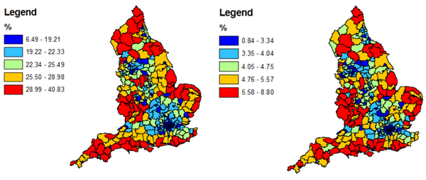
Figure 4: Map of the estimated future distribution of people over 65 years of age (left) and over 85 (right) in England (2031).7
References
- Bayliss, J and Sly, F (2010) Ageing across the UK Regional Trends 42
- Twigger-Ross, C. (2005) The impact of flooding on urban and rural communities Joint Defra / Environment Agency Flood and Coastal Erosion Risk Management R&D Programme R&D Technical Report SC040033/SR1 Product Code: SCHO1005BJTG-E-P
- Zsamboky, M., Fernandez-Bilbao, A., Smith, D., Knight, J. & Allan, J. (2011) “Impacts of climate change on disadvantaged UK coastal communities”, Joseph Rowntree Foundation, York
- Oven, KJ, Curtis, S.E., Reaney, S. Riva, M., Stewart, M.G., Ohlemüller, R. Dunn, C.E., Nodwell, S., Dominelli, L. Holden, L (2012) Climate change and health and social care: Defining future hazard, vulnerability and risk for infrastructure systems supporting older people’s health care in England, Applied Geography, Volume 33, April 2012, Pages 16-24
- Oven, KJ, Curtis, S.E., Reaney, S. Riva, M., Stewart, M.G., Ohlemüller, R. Dunn, C.E., Nodwell, S., Dominelli, L. Holden, L (2012) Climate change and health and social care: Defining future hazard, vulnerability and risk for infrastructure systems supporting older people’s health care in England, Applied Geography, Volume 33, April 2012, Pages 16-24
- Adaptation Sub-Committee (2014) Managing climate risks to well-being and the economy. Progress Report 2014.
- BIOPICCC Research Team (2011) Research Briefing 1: Mapping future risks of extreme weather and growth in older populations in England. Durham University, UK

Built by:
![]()
© 2014 - Climate Just
Contact us