5. Where
- Use the map tool to build up a profile of the neighbourhoods in your area. Consider vulnerability and potential exposure, the nature of vulnerability and different indicators. Look, in particular, for values which are high or extremely high.
- Use the case studies and worked examples in the Further Resources section (Section 6, above) to see how others have made use of the data. Also see our detailed User Guide for flood-related data and the User Guide for heat-related data.
- See Figure 12 (in Section 4, above) for more information about neighbourhood types.
- Determine what broad types of neighbourhoods exist in your area as a result of your profiling work.
- Do you have any extremely vulnerable or climate disadvantaged areas which could be targeted for further action? After further investigation you may be able to construct a case for additional external support to help you to develop responses for some of these areas.
- Do you have any areas which although not extremely vulnerable overall, have particular issues in terms of very high levels of sensitivity or susceptibility, or some of the different social factors? Specific indicators can help you highlight particular groups with specific needs and help you to involve the right partners in developing and delivering appropriate responses.
- Do you have areas which are mainly average or low vulnerability where you could raise general awareness to help communities to help themselves, or where communities might be encouraged to support more vulnerable individuals?
- Do you have areas which are less socially vulnerable but have the potential for high exposure and which should be targeted in terms of raising awareness and promoting self-help, or where physical rather than social solutions might be important?
- Does the profile of your area of interest suggest that other actions might help to reduce impacts, such as establishing more green infrastructure or promoting building level adaptations?
- Verify the data for your area through a combination of local knowledge and additional internal data resources. For example you may want to:
- Involve data departments in your authority or at County level to determine whether there are data at different geographical scales (particularly in rural areas where neighbourhoods cover large geographical areas) or which have been made available after 2011. You might consider the following questions: How can these data be used within the broader framework for understanding social vulnerability and climate disadvantage? What do internal resources suggest about very local areas within neighbourhoods which are not identified in the national data? What trends are apparent in your area? How can the data be used to supplement, develop or replace some of the provided indicators? What are priorities for action for developing the data?
- This activity may also involve selected representatives within your organisation or partners in service delivery with particular specialisms, for example in health, transport, planning, environment, housing or social care.
- Use the data to discuss broad themes and ideas related to vulnerabilities and associated actions and to draw up a set of priorities.
- Discuss the data and local profiles at a meeting with your partners in service delivery and, where appropriate, neighbouring authorities. For example, your use of the data can complement existing internal and external decision-making processes designed to help with flood and coastal risk management (Figure 10). Your activities should also fit within other decision-making processes for local adaptation, e.g. the UKCIP Adaptation Wizard.
- Partner with representatives of the voluntary and community sector and consider how and when to involve local communities in discussions. When using data externally, consider how this can be done without causing unnecessary concern or possibly stigmatising areas, for example through avoiding explicit reference to place names or street names.
- Consider what additional data need to be collected to support your activities. Is it feasible to collect additional data locally or is action required at county and/or national scales? Additional data resources may be available from other tools and resources. See the Further Resources (Section 6, above) for a list of tools that you could use to develop further information on some of the themes in the Climate Just data, and avoid starting from scratch. However, even where data are imperfect, they can still be used to frame discussion.
- Review the Recommended general actions. This includes information about raising awareness and partnership working.
- Review the specific actions associated with particular vulnerable groups. Also consider how multiple priorities can be delivered together for some of these groups, e.g. relating to a range of hazards or relating to a range of ways which individuals and communities might be affected.
- Use the data and information to inform local adaptation plans or other related actions. Updated and refined data from our map tool may also help to support decision-making for required investment in flood defences or considering the impact of planned development.
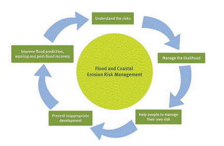
Figure 13: Flood and Coastal Risk Management process for Government activities.1
References
- Defra and the Environment Agency (2011) Understanding the risks, empowering communities, building resilience. The national flood and coastal erosion risk management strategy for England.

Built by:
![]()
© 2014 - Climate Just
Contact us